
Cima Calescio e Camoghè
Information
| Date: | 30 October 2022 |
| Maximum height: | 2228 m |
| Difference in height: | 840 m |
| Length: | 7.8 km |
| Kilometers effort: | 19 kmef |
| Duration: | 4 hours and 30 minutes |
Difficulties (Automatic translation in english)

|
From the Alpe di Serdena to the Cima Calescio and on to an altitude of 2150 metres. |

|
From the altitude of 2150 metres to the top of Camoghè (with some T4 and I grade climbing). |
|
|
From Camoghè to Bocchetta di Revolte. |

|
From Bocchetta di Revolte up to Alpe di Serdena (with some T2+ passages in the first section up to Corte Lagoni). |
Comment (Automatic translation in english)
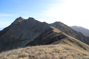
The objective of today's excursion is Cima Calescio, a mountain located near Camoghè, between Val di Serdena and Valle di Caneggio.
First, I reach Alpe di Serdena along the military road that climbs from Isone and is generally open to traffic on Sundays. I then start walking following the track that leads to Travorno Maggiore and then continue along the ridge that climbs northwards. At 1900 metres, I cross the slope to the left until I reach Cima Calescio where there is a small stone cairn. The entire route up to here does not present any particular problems.
Now, however, I want to try to reach the Camoghè from this side since I haven't climbed it since 2009. First I turn back and follow the ridge up to the summit at 2103 metres. I then continue towards the next peak, 2202 metres high, which I climb from the west side. The only stretch that is a little more challenging is at an altitude of 2160 metres, where the ridge becomes steeper and a little more exposed. Nothing too difficult, however. At the summit, the Camoghè stands out in all its beauty right in front of me. Now all that remains for me to do is to descend some 20 metres to reach the saddle separating the two mountains and immediately afterwards climb a small rocky section (grade I climbing, see photo) that allows me to reach the meadows above. Another 35 metres of climbing and I am at the summit of Camoghè where I find another little stone cairn.
Dozens of people are arriving at the summit, so I decide to move near the chapel to eat something. I then start to descend following the official path that leads to Bocchetta di Revolte, after which I continue towards Corte Lagoni where there is a small pond. One last downhill stretch and I finally reach the Alpe di Serdena again.
As for water, there is a fountain at Travorno Maggiore and then a stream after Corte Lagoni.
Map of the Path


")


")


Comments (0)