
Poncione d'Arzo
Information
| Date: | 10 October 2019 |
| Maximum height: | 1017 m |
| Difference in height: | 500 m |
| Length: | 7 km |
| Kilometers effort: | 13.7 kmef |
| Duration: | 4 hours |
Difficulties

|
Lungo tutto il percorso (T1 i numerosi tratti su strada). |
Comment (Automatic translation in english)
One of the most beautiful ways to reach Poncione d'Arzo starts from the sports field of Arzo where there is a bus stop and a parking lot. From this side of the Poncione you can see numerous quarries from which once was extracted the famous marble of Arzo, exported to distant and famous places (such as the Cathedral of Milan). The largest quarry, from which the red gravel was once extracted, has now been transformed into a naturalistic amphitheatre where public events take place.
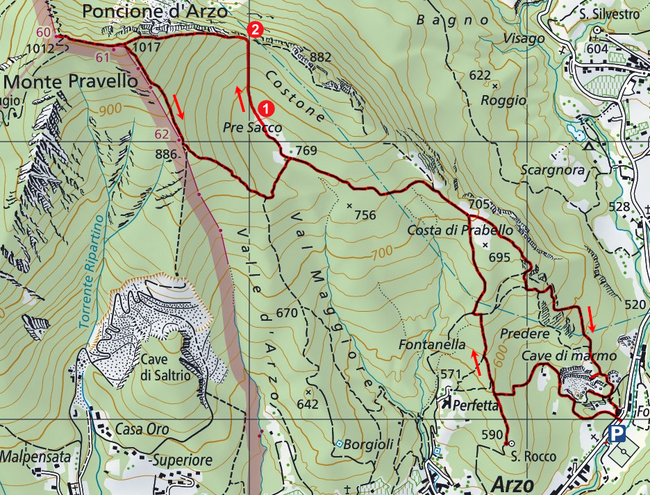
Let's start our tour following the road that goes up to the south of this last quarry. After about 400 meters the road gives way to a path that we follow until we reach the junction at an altitude of 600 meters. We decide to turn left and make a jump to the oratory of San Rocco, after which we return back along the same path until the junction before. We continue in a northerly direction until we reach, around the altitude of 650 meters, the road that climbs from Perfetta. We take it in a northerly direction and we reach in a short time the meadows on the Costa di Prabello and then, after less than 1 km, the meadow of Pre Sacco. At this point we decide to cross the meadow (point 1) and follow an old path that climbs north to an opening located at an altitude of about 860 meters (point 2). This route is not marked on the map, but there are numerous red signs in the trees along the way indicating the way forward. At the mouth of the river we find the path that comes from the east and we follow it along the eastern slopes of Poncione until we reach the summit.
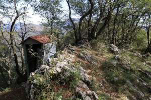
This mountain is composed of 2 peaks. The one just reached is the highest (1'017 meters) and there is a small sheet metal guard once used by border guards. Continuing west in a short time we reach the other peak (1'015 meters) where there is a table, benches, a cross and a second guard, this time in reinforced concrete.
After a break we continue our journey towards the east summit and this time we follow the official path that descends towards the south-east along the border line. We return to the Pre Sacco meadow and then to the Costa di Prabello. At this meadow, however, we decide to follow the path that descends to the south-east and that will take us to visit more quarries. Towards the altitude of 640 meters we reach first the quarry of Predina and then the quarry Allio, where you can still see the signs left by the helical wire once used to cut the blocks of marble. Continuing the descent, we finally return to the natural amphitheatre and the place from which we started.
I remember to bring the right amount of water because along the way there is none.
Map of the Path


Comments (0)