
Schenadüi
Information
| Date: | 29 July 2021 |
| Maximum height: | 2747 m |
| Difference in height: | 980 m |
| Length: | 17.5 km |
| Kilometers effort: | 30.5 kmef |
| Duration: | 8 hours |
| Lakes reached: | Lago di Schenadüi |
| Laghetto della Miniera |
Difficulties (Automatic translation in english)

|
From Lukmanier Pass to the end of the road, at the fork at the altitude of 1924 metres. |

|
From the fork at the altitude of 1924 metres to the fork at 2228 metres (with T3+ passages equipped with chains). |
|
|
From the fork at the altitude of 2228 metres to Schenadüi Lake (with T4 passages before the lake). |

|
From Lake Schenadüi to the Schenadüi summit and back. |
|
|
From Lake Schenadüi to the ford at Stabbio di Mezzo, via the Laghetti della Miniera. |

|
From the ford at Stabbio di Mezzo to the fork at the altitude of 2228 metres. |
Comment (Automatic translation in english)
Today's hike in Val Cadlimo with the aim of reaching Schenadüi, a peak on the border with Val Piora.
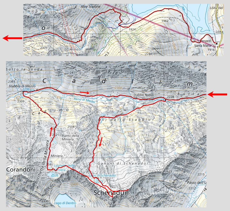
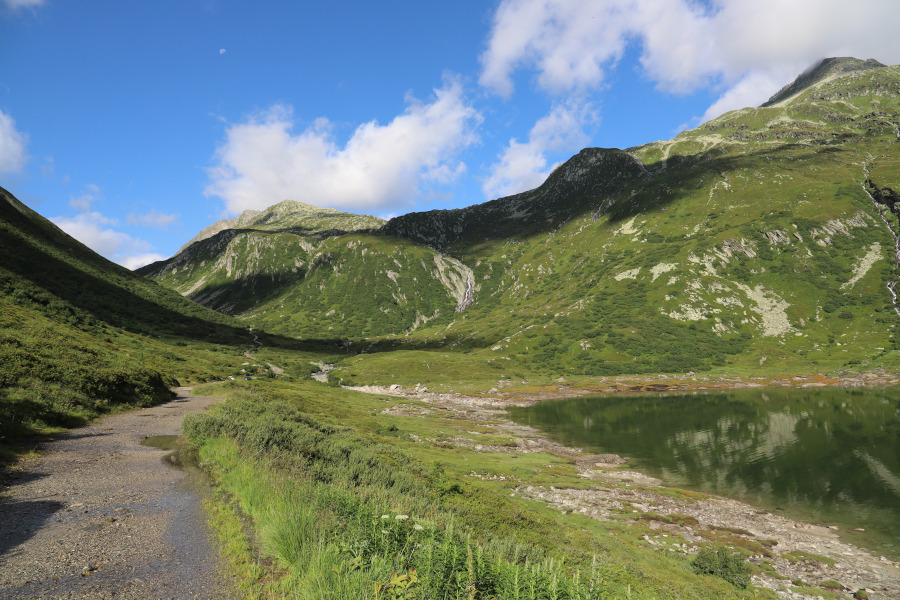
Departure is from the Lukmanier Pass where you start walking along the road that runs alongside the lake and leads into Val Termine. At the fork in the road at an altitude of 1924 metres, leave the road and take the path that crosses the bridge and climbs towards Val Cadlimo. As you go up, the path gets worse and worse until you reach some passages between the rocks, equipped with chains, around 2130 metres. Further on, there are still some rocky passages to cross before reaching the fork at an altitude of 2228 metres. At this point we cross the small bridge and then leave the path and start to climb along the meadows towards Ovi dello Stabbio. When we reach Ovi dello Stabbio, we start to climb straight up towards Lago di Schenadüi, along pastures that gradually give way to stones and finally to real rocky areas. When we reach the lake, we are lucky enough to be able to admire it in all its splendour, thanks to the fact that it is now completely full of water. In fact, it is a temporary stretch of water that can be completely dry at certain times of the year.
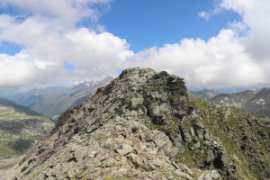
At this point, we begin the ascent to the Schenadüi along its western slope, aiming towards the peak, which is about 2736 metres high (not indicated on the map) and which stands out straight in front of us. Once reached, we soon reach the main summit, on which a large stone cairn has been erected.
On the way back, we retrace our steps up to 2660m, and then climb briefly to the summit at 2680m, from where we can admire the entire Val Piora.
We then descend to Lake Schenadüi from where we continue towards the summit at 2637 metres. A final downhill section takes us to the Laghetti della Miniera, from where we descend to the Cadlimo Valley. When we reach Stabbio di Mezzo, we cross a shallow ford and take the main trail back to Stabbio Nuovo and finally back to the Lukmanier.
As far as water is concerned, there is a small fountain near the Lucomagno hospice and then two streams below Alpe Scaione and one on the way up to Lago di Schenadüi. Afterwards, there is nothing more to be found until the Laghetti della Miniera, where we found another small stream, perhaps a temporary one. On the way back, along the Cadlimo Valley, you will come across several more streams coming from the side of the valley.
Map of the Path


Comments (0)