
Basòdino
Information
| Date: | 9 August 2022 |
| Maximum height: | 3273 m |
| Positive difference in height: | 1530 m |
| Negative difference in height: | 2380 m |
| Length: | 19.5 km |
| Kilometers effort: | 42.7 kmef |
| Duration: | 11 hours |
| Huts reached: | Capanna Basodino |
Difficulties (Automatic translation in english)

|
From Robiei to the fork at Randinascia (with some T2+ passages). |

|
From Randinascia to an altitude of around 2600 metres (with some T3 passages, especially north of the 2402 metre mark). |

|
From an altitude of 2600 metres to the beginning of the glacier (with some T4 passages and a grade II climbing passage). |

|
From the entrance into the glacier to the exit at an altitude of 3100 metres. |

|
The last stretch to the top of the Basòdino, along its east ridge (with many grade II climbing passages). |
|
|
The path leads down from Robiei to San Carlo (T1 the road section). |
Comment (Automatic translation in english)
The Basòdino is a mountain on the border between Valle Maggia and Val Formazza and at 3273 metres above sea level is the second highest peak in Canton Ticino. To reach it I choose to go up to Robiei by cable car (19.- francs one way; 24.- francs return) while on the way back I will walk down, as I already know I won't make it in time to catch the last ride (16:45).
After the cable car ascent, I start walking along the path that climbs to Randinascia and then continue on to the crossroads at 2222 metres, beyond which there are two ascent routes. I choose to walk along the southernmost one, which partly follows the Basòdino glaciological path, and then climb up the glacier moraine to an altitude of 2500 metres. At that point the track disappears and I continue following the little stone cairns and some white paint marks. You now begin to enter the bed where the glacier once flowed and walk on fairly smooth ground. However, there are some rocky jumps that sometimes require a bit of climbing. The most complicated point is encountered at an altitude of 2720 metres where you have to climb a small grade II gully about 5 metres high (see photo). Once past this section I reach a small plateau where the little stone cairns disappear. The last ones seemed to be heading south-west and so I continue in that direction and after a few more small climbing passages I reach the Basòdino Glacier (if you want to climb up to the glacier by an easier route, you can follow the path further north as I did on the trip to Pizzo Cavergno).
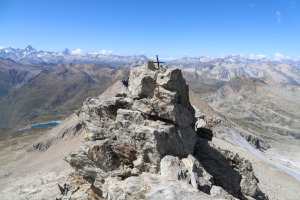
After putting on my crampons, I start to climb it, staying on the right side, where there are fewer crevasses. This year, due to the heat and the scarce snowfall, the glacier is almost completely uncovered and the risk of falling into one is very low. At around 3050 metres, I start to head south and, after circumventing a couple of crevasses, I reach the east ridge of the Basòdino. I abandon my crampons and start to climb it, staying slightly on the right-hand side. This section has many grade II climbing passages and is also a little exposed in places. Once I have passed this part, I finally reach the summit where I find a small iron cross waiting for me.
After a restorative break, not too long because the time is short, I start my descent again because the way back is still long. I reach the glacier and, after retrieving my crampons, I descend it again to an altitude of 2810 metres. Back on the rocks, I start to descend but, unlike the ascent, this time I try to stay more to the right and head towards a small lake. This alternative turned out to be a little easier than the other one, although I then had to cross a raging stream that caused me some difficulty. I then head towards the passage at an altitude of 2720 metres that I encountered in the morning and descend it again. I then continue to an altitude of 2550 metres where, this time, I try to follow the northernmost path. Up to an altitude of 2402 metres it is not too bad, but then one enters a scree and the path becomes rougher. I find that the southern path, followed on the outward journey, is in any case the best.
Continuing to walk, I return to Robiei again, as I had planned, now too late to descend by cable car. I then head for the Capanna Basodino and begin the long descent to San Carlo, which I reach after more than 2 hours. However, the exertions are not yet over because I now have 57 metres of ascent left before I return to the cable car parking area and conclude this trip.
As for water, there is a fountain at Robiei and one at the cable car parking area. Between Randinascia and 2300 metres there are several streams and more on the Basòdino glacier.
Map of the Path


")


")


")


")


Comments (0)