
Pizzo Cavergno
Information
| Date: | 11 August 2023 |
| Maximum height: | 3223 m |
| Positive difference in height: | 1530 m |
| Negative difference in height: | 2380 m |
| Length: | 20 km |
| Kilometers effort: | 43.2 kmef |
| Duration: | 11 hours and 30 minutes |
| Huts reached: | Capanna Basodino |
Difficulties (Automatic translation in english)

|
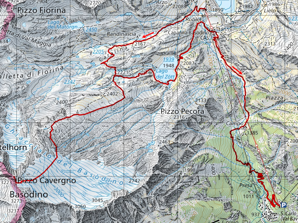
From Robiei to the fork at the altitude of 2221 metres (with some T2+ passages). |

|
From the fork to the altitude of approximately 2600 metres (with some T3 passages). |

|
From the altitude of 2600 metres to the beginning of the glacier at 2810 metres. |

|
The glacier section up to the pass at the altitude of 3152 metres (T4+ the last 20 metres with a slope of around 30°). |
|
|
From the pass to the summit of Pizzo Cavergno (with many I+ grade climbing passages and a few II grade passages). |
|
|
The trail leads from the fork at the altitude of 2221 metres down to Robiei via Lago del Zött (with some T3 passages). |
|
|
The path from Robiei down to San Carlo (T1 the road section). |
Comment (Automatic translation in english)
A year after my ascent of Basòdino, today I return to the same area but to climb the nearby Pizzo Cavergno. Like last year I will climb up to Robiei by taking the cable car from San Carlo (19.- francs one way; 24.- francs return) and then on the way back down on foot as I already know I won't be able to get there in time to catch the last ride (16:45).
From the cable car arrival station I then start walking along the path up to Randinascia and then head towards the fork at altitude 2221 metres. This time, however, I will follow the path further to the west than last year in order to be able to see the Acqua del Pavone cave, the one with the longest development in Canton Ticino (over 3 km). About 30 metres from the path you can see the old swallow hole where the river once flowed. Eighty metres further to the west is the new swallow hole where the river still flows today. Its water, after entering the cave, will travel about 800 metres before returning to the surface above the Lago del Zött.
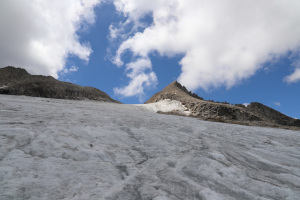
Back on the path, I reach the fork at altitude 2221 metres and start climbing again in the direction of the Basòdino glacier, following the same route as last time. Having reached an altitude of 2560 metres, however, instead of following the stone cairns towards the south-west, I wanted to try following the path that continues west-south-west and is also marked on the national map. There is a track along this route that is clearly visible in some places, while in others it almost disappears. It is not, however, difficult to walk. At an altitude of 2740 metres, the track ends and we continue southwards following the stone cairns. Towards an altitude of 2800 metres, there is a small ridge to cross. On the way out, I crossed it a little too high and then had to descend on the other side, losing a little altitude. On the return journey, however, I crossed further down (see photo). I then reached the base of the glacier exactly where I had arrived last year. I would say that the route followed this year, however, is easier because it does not have any grade II climbing passages.
I put on my crampons and start to climb up the glacier, which is also completely uncovered this time. There are only a few crevasses and they are all between an altitude of 3100 and 3120 metres. After going around them, some on the right and others on the left, I arrive at the last section of glacier, the steepest one, which reaches about 30°. I ascend it carefully until I reach the nozzle at altitude 3152 metres. I then remove the crampons and begin to climb the south ridge of Pizzo Cavergno, staying slightly to the right because there is a precipice on the left. The rock is quite unstable and the boulders do not always offer a secure hold because some of them come loose. Every so often there is a track, but it is made up of gravel and there is a risk of slipping. Having climbed the ridge I finally reach the summit where I find a small stone cairn and nothing else.
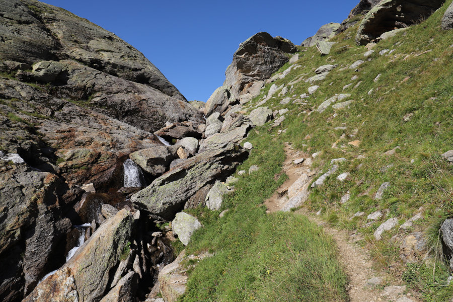
After the lunch break, I descend again by the same route as before until I return to the fork at altitude 2221 metres. At that point I decide to descend towards Lago del Zött to see the resurgence of the Acqua del Pavone, where the river seen earlier returns to the surface again. The path on that side is quite beautiful at first but then, where the steepest section is, it is quite ruined and full of vegetation. Arriving at lake level, at one point the path continues below the surface of the water and one would have to continue swimming to follow it. Whoever designed it evidently did not think that the water level of an artificial lake can change over time. I go higher and reach a river in flood, with a fairly strong water current, which seems insurmountable. However, turning back is out of the question because I would have had to climb 270 metres again. So I try to go up the river for about ten metres until I find a slightly wider spot where there are some rocks to jump on to try to cross. With a bit of effort I finally manage to cross, also thanks to the fact that I had the sticks with me that I could rest on the bottom of the river. I have to say that the path I just took is the ugliest official path I have ever seen and I strongly advise against it. But then it gets better and I manage to go all the way around the lake. There is only a short section that is a bit exposed but equipped with cables and steps before reaching the dam (see photo). This part, however, can be circumvented by following another path, also marked on the national map, which passes about ten metres further up.
Following the road, I then return to Robiei and continue on to Capanna Basodino. At that point I take the path down to San Carlo, which I reach after more than 2 hours. After a final ascent of 57 metres I return to the cable car parking area, where this ends.
Water (Automatic translation in english)
There is a fountain at the car park of the teleferica, one at Robiei and one near the Capanna Basodino. Between Randinascia and an altitude of 2300 metres, there are several streams and more on the Basòdino glacier. On the way back, I then found a few more rivers south of Lago del Zött.
Map of the Path

Summits
Huts


")

")


")

")


")


")


")

")

")


Comments (0)