
Cima del Simano
Information
| Date: | 26 August 2021 |
| Maximum height: | 2579 m |
| Difference in height: | 1220 m |
| Length: | 14 km |
| Kilometers effort: | 30.2 kmef |
| Duration: | 7 hours and 30 minutes |
| Huts reached: | Rifugio Lavill |
Difficulties (Automatic translation in english)

|
From Cascina di Dagro to Lavill (with some T2+ passages). |

|
From Lavill to Alpe Pièi. |

|
From the Alpe Pièi to the Cima del Simano via the Laghetto di Port (with some easy T3+ stony ground). |

|
Direct descent from Cima del Simano to Alpe Pièi. |
|
|
From Lavill to Cascina di Dagro via Capanna Prou (with some T2+ passages). |
Comment (Automatic translation in english)
Today's destination is the Cima del Simano, a mountain in the Blenio Valley that rises above the municipality of Acquarossa.
Departure is from Cascina di Dagro (Dègro), which can be reached by the Malvaglia cable car or by the narrow and endless road from Dandrio. In this case, a toll is charged for access to the valley. Immediately after the Laghetto della Val Malvaglia there is in fact an automatic column for the distribution of tickets to be left on the windscreen of the car. The cost is 5 francs for the whole day.
Once I reach the farmsteads I start walking uphill until I reach an altitude of 1700 metres where I meet two deviations that I pass on the left. I continue to climb towards the Costa di Merlino along an easy path that, however, has some more challenging passages. One of these is found at an altitude of 1760 metres where the path comes very close to the cliff (see photo) and for safety's sake, a chain has been put up to hold on to. I finally reach Lavill, where there is a shelter for 12 people that has been recently renovated, replacing the roof in poplar with a sheet metal roof.
At this point, I leave the official path and start to follow the track that goes up to Alpe Pièi. Up to an altitude of 2130 metres it is quite visible, then you reach a rocky wall that from afar seemed difficult to overcome. In reality, there is a ledge about 1 metre wide that allows an easy passage. After the rocks, the path disappears a little and then reappears 50 metres further up. Following it, I finally arrive at Alpe Pièi.
From the alp, I continue northwards, along easy grassy slopes, bypassing on the left the huge scree slope that descends from the Gana Bianca. The latter is actually one of the biggest rocky glaciers in Ticino. In fact, there is permafrost under the rocks, which moves during the year and causes all the rocks to slide down into the valley. In this case, however, the movement is limited to 2-3 cm per year, while in other places it can reach a metre.
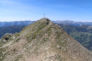
At an altitude of 2400 metres you reach a rocky barrier that you can go around on the left (see dotted path on the map). However, I passed on the right because I wanted to go up and have a look at the Laghetto di Port. Unfortunately, as to be expected, it is completely dry at this time of year. I then headed back towards the Cima del Simano which I climbed along the north-east ridge, where there are some easy scree slopes to cross.
On the summit there is a beautiful cross, probably laid in 1983, and a weather station.
For the return journey, I chose to follow a shorter route and descend directly to Alpe Pièi. Compared to the route taken on the way up, this one is decidedly more rocky, especially around the 2400m mark. However, there are stone cairns to help you follow the correct route. Once reached the alp, I go down again to Lavill where this time I decide to follow the higher path that leads to the Alpe di Prou. However, it is necessary to consider that in doing so, there are another 140 metres of ascent to be done. In fact, this route has numerous ups and downs that increase the difference in height.
When I reach the Alpe Prou, I go to have a look at the Capanna Prou, after which I go back down to Cascina di Dagro, where this excursion ends.
As far as water is concerned, there is a fountain at Cascina di Dagro, one at Lavill and one at Capanna Prou. Higher up, there are a few streams around Alpe Pièi, but they are in the area where the sheep graze and the water may not be reliable.
Map of the Path


")

")

")


Comments (0)