
Gaggio
Information
| Date: | 17 September 2021 |
| Maximum height: | 2267 m |
| Difference in height: | 1050 m |
| Length: | 13 km |
| Kilometers effort: | 27 kmef |
| Duration: | 6 hours and 30 minutes |
| Huts reached: | Baita Arami |
| Capanna Albagno |
Difficulties (Automatic translation in english)

|
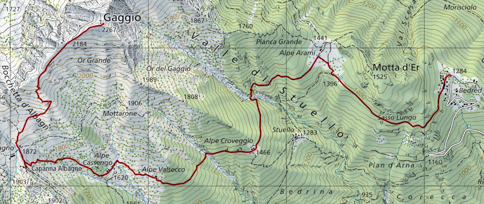
From Bedretto to Alpe Arami. |

|
From Alpe Arami to Capanna Albagno (with some T2+/T3 passages in the Stuello Valley river crossing). |

|
From Capanna Albagno to the summit of Gaggio. |
Comment (Automatic translation in english)
Gaggio is a mountain in the Bellinzona district, situated between the municipalities of Gorduno and Preonzo.
To reach it, you can start from the Mornera cableway or drive up to the Bedretto mountains. In reality, as I only discovered later, it would be possible to go up almost as far as Alpe Arami because the barrier, which is still marked on the national map, has been removed. If you want to drive up, however, you must first apply for a transit permit, either directly to the Gorduno Patriziato or via the Parkingpay app. The cost for one day is 5.- francs.
A new hut, with 12 beds, called Baita Arami, has recently been created at Alpe Arami. Although the official inauguration should take place next year, it is already possible to access the hut.
I climbed up on foot from the Monti di Bedretto and once I reached Alpe Arami, I continued along the path leading to Alpe di Croveggio. After about half a kilometre the path begins to descend towards the bottom of the Valle di Stuello and then rises again on the other side. This section, which used to be a bit bumpy, has been almost completely resurfaced by laying many stone steps. Now, to complete the work, there are only ten metres left and then it remains to fix the river crossing that, for now, remains a bit complicated with passages of difficulty T2+/T3.
After crossing the river I reach the Alpe di Croveggio and continue towards the Alpe Cassengo to finally reach the Capanna Albagno.
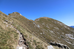
After a moment's rest, I set off again towards Alpe Albagno and then follow the path up the ridge to the summit of Gaggio.
On the summit, the first thing you notice is the big wooden cross, probably placed there in 1996. The view extends from the nearby Cima dell'Uomo to the entire valley floor between Bellinzona and Biasca.
For the return journey I followed the same route as on the way up.
If you need water there is a fountain in Bedretto, one before Alpe Arami and one at Alpe Albagno. In addition, there are several rivers along the path to Capanna Albagno.
Map of the Path


")


Comments (0)