
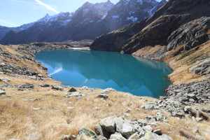
Lago di Morghirolo
Information
| Date: | 19 October 2022 |
| Maximum height: | 2288 m |
| Difference in height: | 1120 m |
| Length: | 16.2 km |
| Kilometers effort: | 31.1 kmef |
| Duration: | 6 hours and 30 minutes |
| Huts reached: | Capanna Campo Tencia |
| Lakes reached: | Lago di Morghirolo |
Difficulties (Automatic translation in english)

|
From the car park in Polpiano to Lake Morghirolo (with some T2+ passages from 1980 metres upwards). |
|
|
From Lake Morghirolo to Alpe Morghirolo (with some T2+ passages). |
|
|
From Alpe Morghirolo to Sgnòi. |
Comment (Automatic translation in english)
Today, after many years, I return to Val Piumogna to climb up to Lake Morghirolo. In 2010 I had been on Pizzo Campo Tencia, but at the time I had not had time to make a diversion to the lake.
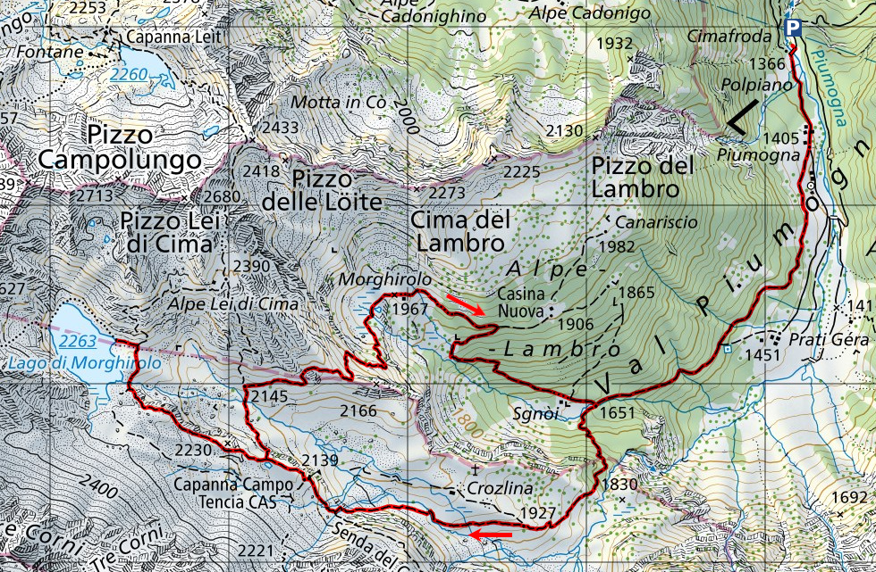
I start by reaching the village of Polpiano where, immediately after the bridge, there is a large car park. I then set off along the dirt road, forbidden to traffic, that leads to Piumogna, after which I take the path that climbs to the right. After about 2 km, slightly uphill, I reach the Sgnòi plateau, cross the bridge and continue on the other side of the valley. Once out of the forest, I continue uphill passing Alpe Crozlina until I reach Capanna Campo Tencia. There is not a soul around and even the hut has been closed early to allow some work to be done. I stop for a moment to rest and then set off again in the direction of the lake, which I reach after a few ups and downs. Here too, as in the hut, there is no one around and it is wonderfully quiet.
After a walk to the north side of the lake (which I have not marked on the map) in order to photograph it better, I start to descend again towards the hut. At an altitude of 2173 metres, I reach the diversions for Alpe Morghirolo and decide to follow it so as not to go back along the same path as before. This variant, however, will involve another 70 metres of ascent before reaching the point at 2189 metres. Afterwards there will only be a descent to the alpine pasture along a path that in places is somewhat hidden by tall grass. I then continue towards Casina Nuova but, just before reaching it, I turn right and follow the path that will take me back to Sgnòi. I then retrace the same route as the outward journey and return to Piumogna and the parking area.
As far as water is concerned, there is a fountain just before Piumogna and then another at the Campo Tencia hut, which is closed at this time, however. There are also some streams before the hut and the Piumogna river.
Map of the Path


")


")


Comments (0)