
Cima est del Witenwasserenstock

Information
| Date: | 14 August 2021 |
| Maximum height: | 3025 m |
| Difference in height: | 1030 m |
| Length: | 11.5 km |
| Kilometers effort: | 25.2 kmef |
| Duration: | 7 hours and 30 minutes |
| Huts reached: | Rotondohütte |
Difficulties (Automatic translation in english)

|
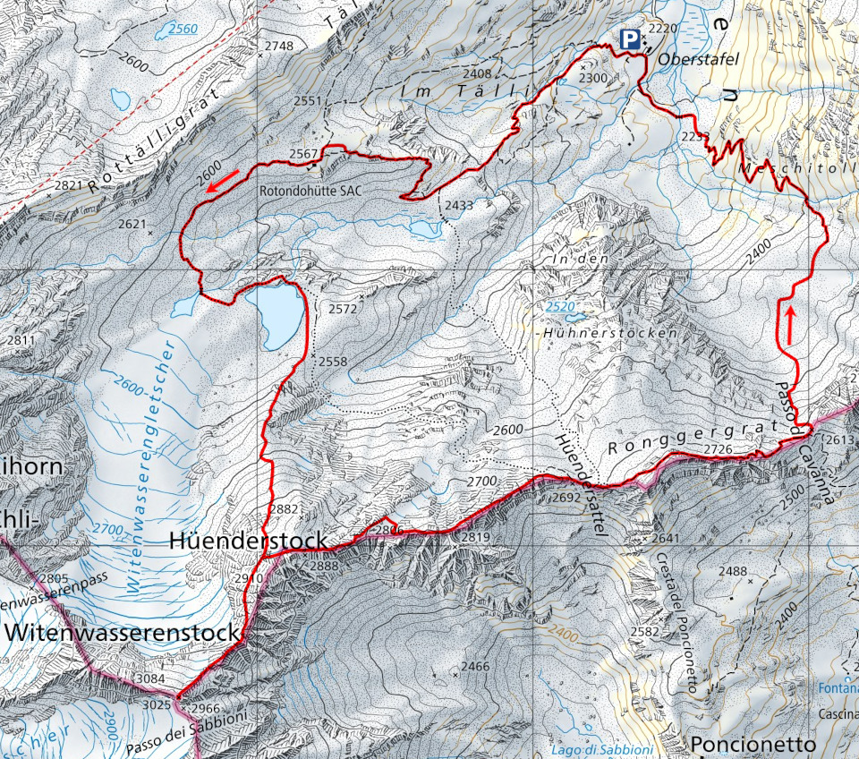
From Oberstafel to the Rotondohütte. |

|
From the Rotondohütte to the fork near the Hüenderstock. |

|
From the fork to the east summit of the Witenwasserenstock. |

|
From the fork near the Hüenderstock to the Hüendersattel. |
|
|
From the Hüendersattel to the Cavanna Pass and then down to the altitude of 2450 metres. |
|
|
The last stretch to Oberstafel. |
Comment (Automatic translation in english)
The Witenwasserenstock is a 3085 metre high mountain on the border between the cantons of Uri and Valais, not far from Ticino. Our objective today, however, is its east summit, 60 metres lower and certainly less difficult.
To reach it, we decided to start in Canton Uri, where there is a military road that climbs from Realp up to Oberstafel. To get there, however, you need to obtain authorisation via the Parkingpay application. The cost is CHF 20.
From Oberstafel we started walking along the easy path to the Rotondohütte. After passing the hut, we continued along a slightly more stony path to the two postglacial lakes located where the Witenwasserengletscher glacier once descended. After passing the lakes, we started to climb towards the Hüenderstock, bypassing the ridge on the west side until we reached the fork to the Witenwasserenstock, at an altitude of approx. 2862 metres. At this point, the blue-white-marked path begins, which leads to the summit while remaining on the Uranian side of the ridge. This section of the route crosses a scree slope that at first glance looks very challenging. In reality, there is a track that crosses it and in some places the stones have been moved to make the path easier.
At the top we found a sort of metal spire with the names of three seas and three rivers written on it. The reason it was placed there is the fact that the eastern summit of the Witenwasserenstock is a continental divide. The water that falls on the east side of the peak will end up in the River Ticino, the water that falls on the south-west side in the River Rhône and finally the water that falls to the north in the Reuss. In addition, the summit is also the meeting point of three different cantons: Canton Valais, Canton Ticino and Canton Uri, of which it is also the southernmost point. The view from the summit also includes the majestic Witenwasserenstock, the northwest face of the Pizzo Pesciora and the Gerengletscher glacier between the two peaks.
After the lunch break, we descend back to the fork near the Hüenderstock and take the path to the Hüendersattel. Although the path is again marked in red and white, this section is still quite rough, with many large stones and even the remains of a small glacier (30m wide). The trail improves a little after the Hüendersattel where we followed the path to the Cavanna Pass. The first section is uphill (approx. 50 metres difference in altitude) after which we meet the old military mule track built during the First World War at the highest point. We follow it easily, as it is wide and flat, for about 400 metres until we reach the Cavanna pass. At this point, we descend along a path that is still a little stony until we reach the pass and then continue on the Uri side, along a scree slope, until we reach an altitude of approximately 2450 metres. The boulders are now finished and we continue on a normal path back to Oberstafel. The only thing to watch out for is the ford just before the car park, which can cause a number of problems when the river current is strong.
If you need water to drink, there is a river 600 metres after the Rotondohütte and then another, coming down from the Cavanna Pass, at an altitude of 2400 metres.
Map of the Path


Comments (0)