
Pizzo Corandoni e Pizzo Taneda
Information
| Date: | 18 June 2022 |
| Maximum height: | 2667 m |
| Difference in height: | 1150 m |
| Length: | 14 km |
| Kilometers effort: | 29.3 kmef |
| Duration: | 7 hours and 30 minutes |
| Huts reached: | Capanna Cadagno |
| Lakes reached: | Lago Cadagno |
| Lago di Dentro | |
| Laghetto della Miniera | |
| Lago dello Stabbio | |
| Lago Scuro | |
| Laghetto di Taneda Superiore | |
| Laghetto di Taneda Inferiore |
Difficulties (Automatic translation in english)

|
From Cadagno to Lago di Dentro. |

|
From Lago di Dentro to the Laghetti della Miniera (with some T3+ passages). |

|
From the Laghetti della Miniera to Pizzo Corandoni (with some T3 passages). |

|
From Pizzo Corandoni to Lago dello Stabbio (with some T4 passages). |
|
|
From Lago dello Stabbio to Pizzo Taneda and descent to Lago Scuro (T3 / T3+ above 2600 metres). |
|
|
From Lago Scuro to Cadagno. |
Comment (Automatic translation in english)
Here we are again in the Ritom region, this time to climb Pizzo Corandoni and Pizzo Taneda.
We first reach Cadagno by car along a road closed to traffic between 9:00 and 17:00 (in the opposite direction it is closed between 9:00 and 12:00). There is then a large pay car park (CHF 15.- for the whole day).
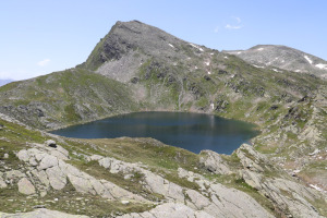
We then start walking towards Alpe di Piora and Capanna Cadagno, where we take the path up to Lago di Dentro. We then continue on to the Laghetti della Miniera along a slightly more difficult path (T3/T3+), which in our opinion does not deserve the blue-white markings with which it is marked. From the little lakes we reach the remains of some stone buildings where we turn left and begin to climb towards Pizzo Corandoni. Following a small valley, we manage to reach the summit without much difficulty.
After a break, we begin our descent on the other side of the mountain, where the terrain is more stony. Without too much difficulty, we manage to reach the Bocchetta degli Oréi and continue around the peak, which is 2481 metres on the right. This last stretch has some rocky slabs to cross and perhaps it would have been easier to climb to the top and descend on the other side instead of bypassing it.
Having arrived at Lago dello Stabbio, we head towards Pizzo Taneda, bypassing it on the north side. In the first section, we cross some easy pastures, then, as we continue to climb, rocky areas appear, especially from an altitude of 2600 metres upwards. There are numerous stone cairns on the summit and the view can sweep over the entire Val Piora.
For the return journey, we decide to descend towards Lago Scuro, following a track that goes around it from the north and then rejoins the path coming from Capanna Cadlimo. Following the latter, we soon reach the Bassa del Lago Scuro. We then continue to the Laghetti di Taneda and then take the path that leads to Cadagno without descending to Lake Tom. In this way we avoid an extra 50 metres of ascent. You just have to be a little careful because in the first section, in the Buco di Tom area, the trail is not very visible and you risk going over. But then, further down, it gets better.
We finally reach Cadagno where our tour ends.
As for water, there is a fountain on the way up from the Capanna Cadagno towards Lago di Dentro, at an altitude of 2096 metres. Then there are a few streams along the path to the Bassa del Lago Scuro.
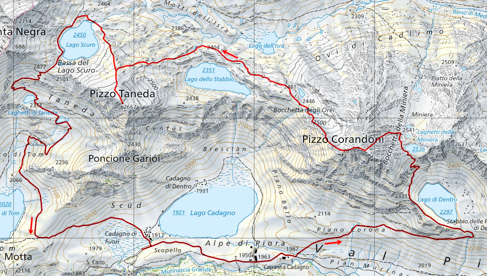
Map of the Path


Comments (0)