
Pizzo Forno
Information
| Date: | 23 August 2022 |
| Maximum height: | 2907 m |
| Difference in height: | 2070 m |
| Length: | 19.5 km |
| Kilometers effort: | 47.1 kmef |
| Duration: | 11 hours |
| Huts reached: | Rifugio Alpe Sponda |
| Lakes reached: | Laghetto Gardiscio |
Difficulties (Automatic translation in english)

|
From the parking area in Valle to Rifugio Alpe Sponda (on both trails). |

|
From the refuge to an altitude of 2540 metres (with some T3 passages). |

|
From an altitude of 2540 metres to an altitude of 2840 metres (with some T3+ passages). |

|
From an altitude of 2840 metres to the summit of Pizzo Forno. |

|
From Passo di Ghiacciaione to Laghetto Gardiscio (with T4 passages). |
|
|
From the lake to the path that descends to the Rifugio Alpe Sponda, at an altitude of 2190 metres (with T3 passages). |
Comment (Automatic translation in english)
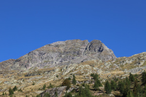
Pizzo Forno is a mountain in the Leventina Valley that is easily recognisable by its pyramid shape and thanks to its panoramic position, it can already be seen from Biasca. To reach it I chose to start from Val Chironico, where there is a large car park in the Valle area.
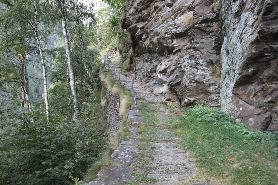
I then start walking, following the path that goes up to Sgnoi. Towards an altitude of 1,100 metres I pass a rocky stretch thanks to a spectacular mule track, partly dug into the rock, which ascends in numerous hairpin bends. I then continue towards the village of Cala (called Cára on the new national maps) where I stop for a moment to admire the interior of the Oratory of San Bernardo, in which there are numerous paintings. I then cross the entire village and take the unofficial path that goes straight up to the crossroads at 1825 metres. At that point, I reach a wooden sign indicating the direct route to Rifugio Alpe Sponda. This path, which is not marked on the map, instead of continuing on the level, climbs immediately northwards and almost completely bypasses Alpe Sponda, returning to the official path a little higher up. Since I have read and heard some unpleasant stories about shepherd dogs on the alp, I decide to follow this route to avoid trouble. I later discover that at this time, there is no sign of any dogs.
I arrive in this way at the hut, where I stop for a moment to eat something. I then start to climb again in the direction of the Passo di Ghiacciaione along a fairly signposted path, the trace of which, however, is barely visible. At an altitude of 2,575 metres, I reach a rock with the turnoff for Pizzo Forno indicated in white paint. I follow it and discover that it heads towards the south ridge of the mountain, to then climb it and reach the summit. Along this stretch, which is rockier than the previous one, especially towards the summit, there are white signs indicating the route to follow. On the summit, however, there is a small stone cairn with a notepad instead of a summit book.
After an hour's break, I start to descend again, along the same route as before, to an altitude of 2730 metres. At that point I leave the route to go and see the Ghiacciaione Pass and then cross the scree remaining at more or less the same altitude. Having reached the pass, since there is still time, I decide to also go and see Laghetto Gardiscio, which is only 1 km away as the crow flies. In reality, this stretch will prove to be more difficult than expected due to the numerous rocky valleys to cross and will take almost 1 hour to overcome. However, it will be worth it because the small lake is really very beautiful.
For the descent I decide to follow some yellow paint signs, which start on the south-east side of the lake and which I thought would lead me back to the path to Alpe Sponda. After 200 metres they turn right instead and start to descend towards Alpe Gardiscio. In hindsight I would have done better to abandon them and continue directly towards the point at 2526 metres. Instead I decide to follow them, hoping that they will not lead me too far out of line with my destination. Finally at around 2400 metres they turn east again and head in the right direction. Unfortunately, however, after only 450 metres they abruptly stop with one last T-shaped mark and no more can be seen. I then continue straight on for another 400 metres until I reach a large rocky drop that cuts me off. I then go around it to the right, descending about 60 metres and then heading east again. After crossing a few more small valleys I finally reach the official path, which I descend again to Alpe Sponda. At that point, seeing that as in the morning there is no sign of dogs, I try to follow the official path down to the junction at 1825 metres. I then continue on to Cala from where I finally descend again to the parking area in Valle.
Water (Automatic translation in english)
There are two fountains at Cala and one at Rifugio Alpe Sponda. Afterwards, I found a few more streams near Alpe Gardiscio.
Map of the Path


Summits
Huts
Lakes


")


")

")


")


Comments (0)