
Poncione di Braga
Information
| Date: | 3 August 2022 |
| Maximum height: | 2864 m |
| Difference in height: | 1700 m |
| Length: | 17 km |
| Kilometers effort: | 39.6 kmef |
| Duration: | 10 hours |
| Huts reached: | Capanna Poncione di Braga |
| Lakes reached: | Lago della Froda |
Difficulties (Automatic translation in english)

|
From Ghéiba to the Capanna Poncione di Braga. |

|
From the hut to the Filo della Tanèda (with some T3 passages). |

|
From the Filo della Tanèda to an altitude of 2680 metres, before leaving the official route. |

|
From the altitude of 2680 metres to the top of Poncione di Braga. |
|
|
From the Filo della Tanèda to the fork at the altitude of 1844 metres. |
|
|
From the fork to Ghéiba (T1 the road sections). |
Comment (Automatic translation in english)
The Poncione di Braga is a mountain on the border between the Val Bavona and the Valle di Peccia. I decided to start from the latter, even though the climb on this side is longer, in order to pass by the Capanna Poncione di Braga, which I had never seen before.
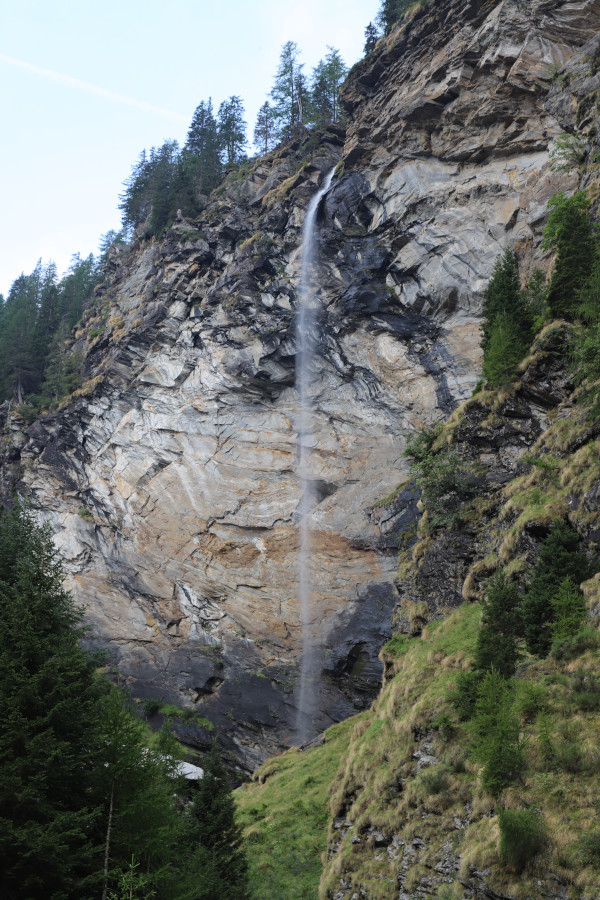
I start by reaching Piano di Peccia and continue to the village of Ghéiba where there are some open spaces where I can leave my car. I then cross the bridge and begin to climb along the path that leads to the hut. Having arrived at an altitude of 1451 metres, I begin to see the Cascata della Crosa in front of me, which at 129 metres is one of the highest in Canton Ticino. It is just a pity that in this dry period it is a bit dry. Continuing to climb, I arrive at the crossroads at an altitude of 1641 metres and discover that the official path now goes directly up to the point at 1776 metres. On the national map, on the other hand, it is still indicated that it turns left in the direction of the Corte di Fondo di Sròdan. I nevertheless decide to follow the latter route to have a look at the court and then join the official path at junction Q1776. In fact, this section of the path is disappearing a bit, especially near the Corte di Fondo where you can hardly see anything.
Back on the official route, I continue to climb until I reach the Capanna Poncione di Braga where I stop for a moment to eat something. I then set off again in the direction of the Filo della Tanèda along a path that is slightly less visible than the previous one. I then follow the path that leads to the Bocchetta della Froda where the rocks, not very present at the start, increase as I climb. The track is not very visible but there are many white and red signs indicating the route to follow. Every now and then, Lake Froda peeps out to my right, but I decide to stop and photograph it only on the way back, as it is necessary to leave the path in order to get back on it.
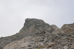
Having arrived at an altitude of 2680 metres, I decide to leave the marked path and start heading towards my destination. After 150 metres I reach a rocky drop (see photo) which I manage to cross and then head towards the scree on the left. I climb it until I reach the north ridge of the mountain, which I will walk along until I reach the summit of Poncione di Braga. In reality, however, the real summit is 15 metres further south and is marked by a large stone cairn. To reach it, however, one must first descend a small rocky drop (II° grade climbing) about 2 metres high and then climb back up the other side.
After my lunch break, I start to descend from the summit in the direction of the previously traversed scree slope. This time I try to cross it by staying more to the right to avoid the rocky drop that I had climbed on the way up. I then walk towards Lago della Froda where I will leave the path for a moment in order to photograph it better. Having arrived at Filo della Tanèda, I take the path that descends to Piatto della Froda and continue until I reach the junction at an altitude of 1844 metres. At that point, partly following the road and partly following the paths, I descend to Sassello and finally return to Ghéiba.
Water (Automatic translation in english)
There is a fountain at the Capanna Poncione di Braga hut (marked "water not controlled") and then the river that descends from Lago della Froda.
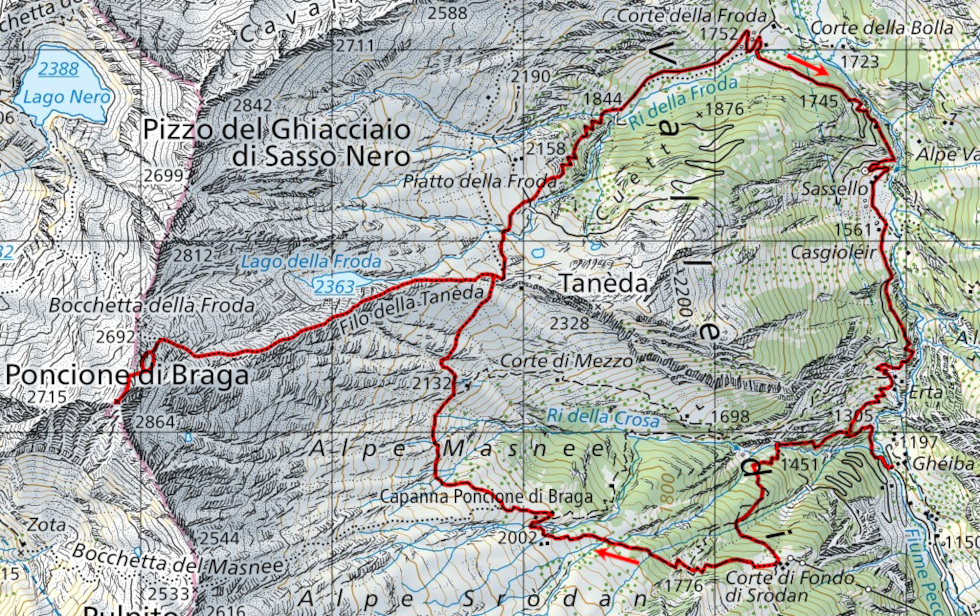
Map of the Path

Summits
Huts
Lakes


")

")


Comments (0)