
Pizzo dell'Uomo e Siwerbenhorn
Information
| Date: | 2 July 2022 |
| Maximum height: | 2765 m |
| Difference in height: | 760 m |
| Length: | 11.5 km |
| Kilometers effort: | 21.6 kmef |
| Duration: | 5 hours and 30 minutes |
Difficulties (Automatic translation in english)

|
From the Lucendro dam to the altitude of 2450 metres, near the Valletta Lake (with some T2+ passages). |

|
From the altitude of 2450 metres to Pizzo dell'Uomo (with some T3 passages, especially on the ridge). |

|
From the pass at 2644 metres to below the summit of the Siwerbenhorn at 2735 metres. |

|
From the altitude of 2735 metres to the summit (T4+ to the south summit with 1 grade II climbing passage). |
|
|
The descent to the altitude of about 2650 metres (with some T3+ passages). |
|
|
From the altitude of 2650 metres back to the path above Cascina della Gana. |
Comment (Automatic translation in english)
Today we set off for the Gotthard Pass region with the intention of climbing the Pizzo dell'Uomo and the nearby Siwerbenhorn.
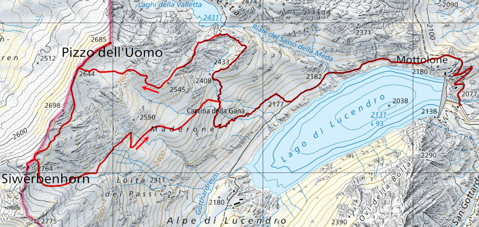
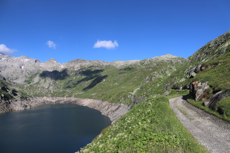
First, we follow the road from the Lucendro Dam along the lake until we reach the junction at 2177 metres. At that point, we take the path up to Cascina della Gana and follow it until we reach above the Lago della Valletta Inferiore. At that point we abandon it and continue following a gully that climbs up to the peak at 2545 metres. We then turn right and ascend the easy slopes until we reach the pass at an altitude of 2645 metres. At that point, following the ridge, we soon reach the summit of Pizzo dell'Uomo, from where we can admire Lake Orsirora.
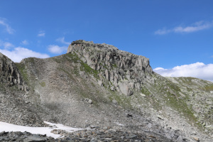
After a short break, we retrace our steps along the ridge back to the bocchetta, where we begin to climb on the other side. We decide, however, to go around the 2698 metre peak on the left because the route seems slightly easier and we can even glimpse a slight trace at first. Without too much difficulty, we then reach the slopes of the Siwerbenhorn where a final, rockier section awaits us before we reach the summit. There is no sign on the exact summit, but instead we notice an old wooden cross some twenty metres to the south-west. It is located on a slightly lower antecedent and while we are at it, we decide to reach it. This section is a little more challenging than the previous one, and after descending to a small saddle, a short grade II climbing passage awaits us to climb back up the other side. From the summit we can observe the Witenwasseren valley where we were last year and at times we can also see Pizzo Lucendro shrouded in mist.
It is time to return and we start to descend again to the slopes of the Siwerbenhorn. At that point, we head first south and then turn east and descend until we rejoin the trail just above Cascina della Gana. The first part of this descent is a little rocky, but then the pastureland increases and we even find a small track leading downhill. Having reached the path, we follow it to Lake Lucendro where, after a final stretch, we arrive back at our starting point.
Water (Automatic translation in english)
There is a fountain below the Lucendro Dam and then some streams above Cascina della Gana.
Map of the Path

Summits


")


Comments (0)