
Pizzo della Valletta - Cima sud
Information
| Date: | 24 June 2026 |
| Maximum height: | 2758 m |
| Difference in height: | 750 m |
| Length: | 11.8 km |
| Kilometers effort: | 21.8 kmef |
| Duration: | 6 hours |
Difficulties (Automatic translation in english)

|
From the Lucendro dam to Alpe di Lucendro. |

|
From the alp to the Lucendro Pass and then up to the altitude of 2,620 metres (with a few T2+ sections). |

|
From the altitude of 2,620 metres to the altitude of 2,730 metres. |

|
The final stretch to the south summit of Pizzo della Valletta and then the descent to the altitude of 2,600 metres. |

|
From the altitude of 2,600 metres to the path at the altitude of 2,475 metres. |
Comment (Automatic translation in english)
With the intense heat we’ve been having of late, the best thing to do is head up into the mountains, so I decide to go to the Gotthard Pass region – and more specifically, to Pizzo della Valletta. However, instead of going via the San Gottardo Valley, as I did last year when I climbed the Fibbia, this time I’ll be ascending from the other side, namely from the Lucendro Pass.
After reaching the dam at Lake Lucendro, I start walking along the road that runs alongside the lake until I reach Alpe di Lucendro. I then continue along the path that climbs southwards until I reach the unnamed lake at an altitude of 2,481 metres. Right next to it is a large stone marking the spot where the River Reuss rises. In fact, the ‘Four Springs’ trail passes through this spot, linking the source of the Rhine to that of the Rhône via the St Gotthard Pass.
After a short climb, I reach the Lucendro Pass, after which I leave the official trail and head north-east. After about 80 metres, I come to a track – probably built by the military – which climbs along the ridge and makes the going easier. I follow it up to an altitude of 2,620 metres, where the first scree slope appears; it’s already quite challenging and continues for another 50 metres of ascent. Once past this, the rocks become smaller and the slope becomes less steep and easier to follow.
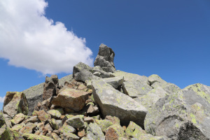
By now, the southern summit of Pizzo della Valletta is not far off. However, during the final 30 metres of the climb, I still encounter quite a few difficulties because the rocks are quite large and it is not always easy to find a way round them. Sometimes there are also quite deep gaps between them that I have to climb over. Finally, I reach the summit, where there is a sort of natural cairn, formed by a few large boulders.
I stop for lunch and then begin to descend down the north-western side of the mountain, with the idea of perhaps also climbing the northern summit of Pizzo della Valletta. Although lower than the previous one, this would be the main summit of the two and the one named on the national map.
However, the descent towards the pass at an altitude of 2,642 metres proves more challenging than expected, as there are also fairly large boulders on that side that I have to work my way round. After about 100 metres of descent, it starts to get a bit late, and the northern peak – which I can now see up close – also presents a fairly difficult climb. I therefore decide to give up on the second peak and perhaps tackle it in the future.
I then descend along the gully heading west, before rejoining the path at an altitude of 2,475 metres. From there, I head back towards Alpe di Lucendro and, following the road, return to my starting point.
Water (Automatic translation in english)
There is a fountain with a tap just below the Lucendro dam, but it was closed today. I’d found it open in the past, but it seems it’s still too early this year.
There are also several streams leading up to the Alpe di Lucendro, but they are difficult to reach as they run beneath the road and the slope is steep. The easiest place to collect water is the River Reuss, which you come across just before the Alpe.
Finally, there should be some streams just before the Lucendro Pass, but today they were covered in snow and I didn’t see them.
Map of the Path



Summits


Comments (0)