
Giro del Monte San Giorgio

Information
| Date: | 13 October 2020 |
| Maximum height: | 843 m |
| Difference in height: | 530 m |
| Length: | 12.5 km |
| Kilometers effort: | 19.5 kmef |
| Duration: | 4 hours and 30 minutes |
Difficulties (Automatic translation in english)

|
Along the entire route (T1 the road sections). |
Comment (Automatic translation in english)
Today's trip to Monte San Giorgio. This time, however, instead of climbing to the top, I decided to walk around it following the geo-paleontological path. This path was inaugurated a few years ago and allows, in addition to a nice walk, to get to know some of the most interesting places of Monte San Giorgio.
To begin with, you have to reach the village of Meride where there is a bus stop and several car parks. Then the path officially goes around the mountain in an anti-clockwise direction, but I preferred to follow it in the opposite direction.
I then started walking towards the countryside of Meride until I reached the area of Spinirolo, where there is a tall chimney. Here there was once a factory for the extraction of saurol, a medicinal oil once used to treat skin diseases, from bituminous shale.
Continuing to follow the path, we then reach the Crocefisso area, where the trail begins to descend to a place called Acqua del Ghiffo. Here there are two quarries (lower and upper) discovered almost 100 years ago in which several excavation campaigns have been carried out, bringing to light dinosaur fossils that had never been discovered before.
At this point, after a short climb, the trail heads towards Alpe di Brusino, where it is possible to admire not only the view but also several centuries-old chestnut trees. Once past the alpe, continue for another stretch until Pianesc, the most northerly point of the entire excursion, where the path turns sharply to the right until it reaches the point at 823 metres. At this point there is a small rocky outcrop on which a flag has been placed, which is also visible from the motorway across the lake.
At this point, you begin to descend towards Albio until you reach the altitude of about 500 metres where, in the Rocul area, a new path has been dug out that continues on the flat and avoids going down further. After about one kilometre, the path crosses the Val Serrata and begins to climb again until it reaches Meride. If you are interested, you can visit the fossil museum in the village, which was completely renovated a few years ago.
Water (Automatic translation in english)
There is little water along the route. There is a fountain in the piazza in Meride and a wash-house in the Fontana di Meride area where, however, water must be taken directly from the basin.
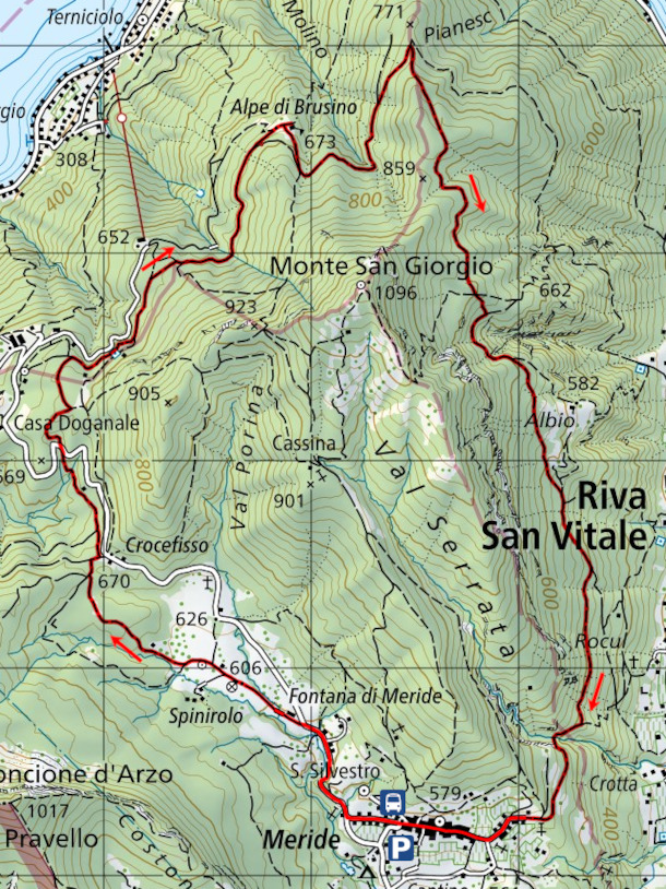
Map of the Path

Other


Comments (0)