
Lago di Sfii (Sfille)
Information
| Date: | 9 September 2020 |
| Maximum height: | 1930 m |
| Difference in height: | 820 m |
| Length: | 12 km |
| Kilometers effort: | 22.9 kmef |
| Duration: | 5 hours |
| Lakes reached: | Lago di Sfii (Sfille) |
Difficulties (Automatic translation in english)

|
From the car park to the end of the road. |

|
From the end of the road to the bridge under the Alpe di Sfii. |

|
From the bridge below the Alpe di Sfii to Lake Sfii. |
Comment (Automatic translation in english)
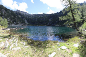
Today's goal is Lago di Sfii in Valle di Campo, also known by many as Lago di Sfille.
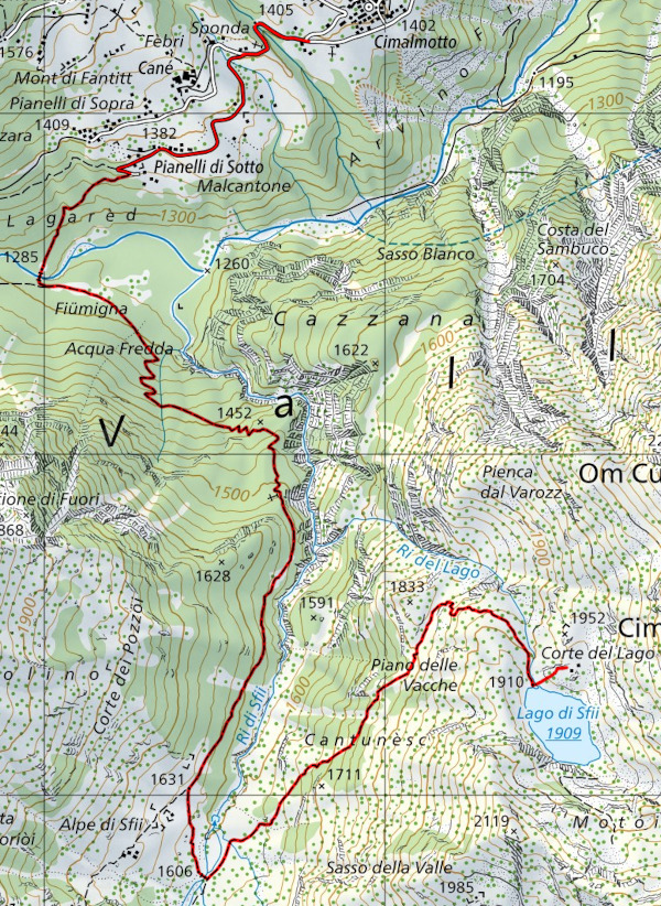
Once you have reached and passed the village of Cimalmotto (where there is a general no-trespassing sign), start walking along the tarmac road that descends towards the bottom of the valley. In the Pianelli di Sotto area, the road ends and the path begins, continuing to descend until it reaches the bridge that crosses the Rovana di Campo. After crossing the bridge, we start to climb up the southern side of the valley along a fairly wide path with numerous steps at the steepest points. After an initial stretch of fairly steep ascent, towards an altitude of 1500 metres, the route continues more gently until it reaches Alpe di Sfii, which, however, is not reached. Just before the alpe, in fact, there is a fork where you must take the path on the left that descends to the river and crosses it on a convenient bridge. After crossing the bridge, start climbing again in a north-easterly direction and, after circumventing a mountain ledge, you will finally reach the lake.
This lake is a beautiful green colour and is completely surrounded by larch trees that in autumn turn the whole area a beautiful yellow colour. In order to get a better view of it, I climbed up to Corte del Lago, where there are still two stone buildings.
The return journey follows the same route as the outward journey.
Water (Automatic translation in english)
There is a fountain along the road just after the village of Cimalmotto and the stream at an altitude of 1380 metres. There is then possibly still the river below the Alpe di Sfii where cows sometimes graze.
Map of the Path

Lakes
Other


Comments (3)